The Full Moon, in opposition to our Sun, attracts Earth- creating a
slightly moving Bulge along a sinuosoidal daily path; within 5 days, this creates
volcanodiscovery.com via microcracks- later enlarging to Fractures:
During the New Moon, our Moon and Sun are combined on one side of Earth (Conjunction) to increase the chance of an
earthquake.usgs.gov along the daily path beneath the Moon- shown as the Third Quarter:
Daily, our Earth presents a moving Attraction target to our Moon, and has over 1/30th of an orbit of our Moon as it augments Jerks= d(acceleration)/dt= 2nd derivative of Earth's velocity dv/dt. This is a noticeable quake over the entire Earth, whenever the Moment 6.1M is exceeded!
Monthly, our Moon makes a complete 360 degree Orbit around Earth, and the Barycenter of the duo (1700 km below Earth's surface, or 25 percent of its radius) make a Sinusoidally-moving oscillation about this Center of Mass; this yields a slight tilting of the surface- resulting in river Meanders, where water erodes first one bank, monthly, and later the opposite one, to make an "S" or the reverse over time.
Quail Creek- being dammed- forms Quail Lake, and the original Meander Arc of the west side is shown below:
Virgin River at the Hurricane fault Hf is anomalous and makes more than a complete turn reversal- 270 degrees below the uplift of the CCW Colorado Plateau Cp:
Great Meander at the 180 reversal of the San Juan River makes an "S" upon close inspection to the north- Rising for the "S" portion (Canyon cutting- not old age, but Youthful):
Arcuate sides of an Evaporitic Pan (Playa lake) have been influenced by barycenter "Rocking":
Erosion of Jurassic sandstone Jn Navajo forms a Figure 8 due to the undulation of the level surface, below:
Increasing the Time Interval IT, our Moon "Rocks", even though it is "Gravitationally locked" with Earth; this jerks on the Earth's crust (decreasing with depth), yielding quakes. Extra 9 percent of our Moon may be seen over a 28.5 to -28.5 degree change of its 5.145 degree inclination over a 18.6 year period:
Death Valley alluvial fan and outwash plain are formed by the 100,000 year- or less- Rocking of the eroding surface:
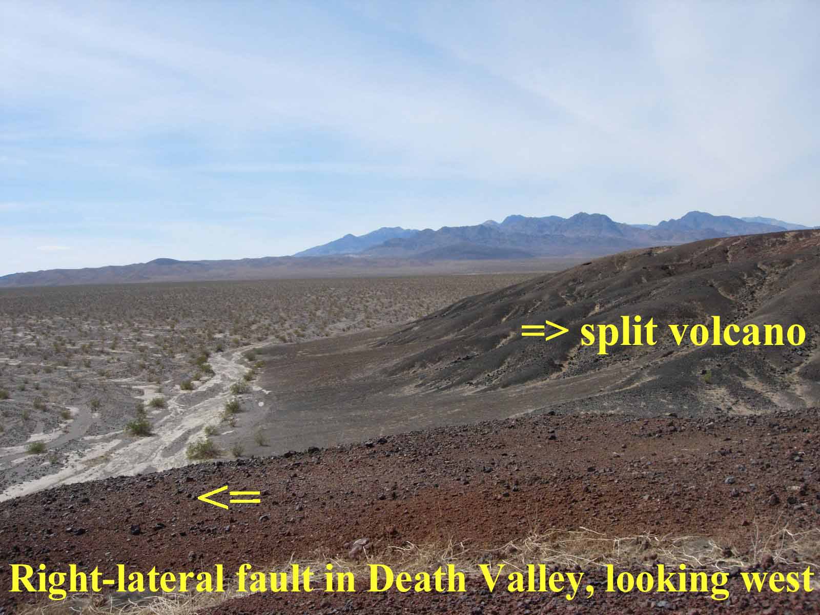
Death Valley DV- moving North along a lateral fault- yields a split volcano; Earth Tides are partly formed by our Moon, with a M/Sun ratio of 2.16 (experimentally):
Orientatiom of Extrusions is N-South, which case hstories show to be due to our Moon (perpendicular to our Sun, which rises in the East toward the west). This is still speculative and we will search further; below are actual photos made by me for the times shown:
Zion pools show the "Hole with a Slice" phenomenon- which is N-South oriented, and which illustrates the formation of Fractures from Erosion (preferentially Left)- moving West more than to the right:
Illustrating the Moon's N-South influence, I speculate that Greenland's orientation and 2.14 Ratio is that of our Moon and Sun (width), as shown below. Photo is rotated 90 degrees- north to left:
Venus, with a Moon transit. has influence on Earth Gravitationally also; below is one from space, and this body exerts the third attraction and "locked in" relation, after our Moon:
Spikes of mass about Venus makes it appear- Gravitationally- wider:
Caspian Sea and Karabugas Evaporitic basin at 55E is tilted by its Venus intermediate relation:
Back to our Moon, which is dominant, and to features, like Alaskan Lynn Canal- which orients almost N-South; Inclination from the Ecliptic is 5.145 degrees, and allows some departure:
Moon path is Arcuate as it crosses the sky in our monthly view:
Our Moon is seen above the Arctic Circle- Pt Barrow, Alaska, where the sun is at the horizon:
Personally, our Moon has many subtle influences on all life, as does the sun- shown for their centers of mass, called Barycenters; these create Gyrations:
Alaskan severe Quake killed many in 1964, after I visited Anchorage, AK:
Above- what does the Moon have to do with Jerks? It supplies the Gravitational Energy, and a trigger from Planets yields an earthquake.usgs.gov, according to the sequence: Jupiter and its Asteroids, Saturn, Venus, while Mars has little correlation since it is Dead- Life organisms wise:
Jupiter and smaller planets along the green Ecliptic, with Inclinatons from it:
Speculated is that the Great Red Spot, GRS, influences our weather, but that's difficult to prove
weather.msfc.nasa.gov
Ecliptic line on a 2D plane of Earth and Sun is approximated (inclinations of all bodies are greater than zero) as \ on the sky below:
Clair de Lune and Beethoven's Moonlight Sonata have a tremendous effect on Romance, and I'll find it here somewhere:
Amptheaters in almost-vertical sandstone Arc with time- suspected to rotate perpendicularly to the horixontal CCW Rise- going CW as shown below:
Distant is the Arc, creater by Erosion from arcuate fractures: orienting E-West, the influence of both our Sun and Moon is suspected:
South Africa craton affects all with its Gold from the PreCambrian, as do other cratons of Australia and Canada; these stable portions of Crust are situated in LaGrange equilateral triangles ET, and now have few quakes, no volcanoes, and remain with no Earth Tides, except at the edges:
Contrast S. Africa with a region with continuous Activity- the S. America jut or Cape at Talara, Peru, with quakes and transforms: earthquake.usgs.gov
Smallest feature I visited was Baby Island, Washington where clams could be harvested and shucked- creating a white shell beach- along a regional Fault:
Hiway 9, Laverkin, Utah- as seen by Google Earth- is anomalous, with a SO2 stink, River S turn, and sinking:
Death Valley DV is an extreme anomaly- that I have hiked many times, and it rivals the Dead Sea in below sealevel activities:
Dead Sea, Israel is the deepest sink, and is now thought to be augmented 3700 years ago by a Strike; location of the strong brine (no outlet- evaporation only). See recent Excavations.
Dead Sea potholes indicate that sinking continues; smallest size suggests North Earth Tides:
GE Dead Sea and analysis for Earth Tides shows expansion to the SW: